
Freund Canyon, Ski Hill, Ranger Road Trails (<10 miles)
Xanadu Trail (? miles)
Red Hill-Devil's Gulch-Mission Ridge Trails (<20 miles)
Canyon Roads Branching From Chumstick Highway (? miles)
Icicle Ridge Trail (1-? miles)
Sage Hills Outside of Wenatchee (1-? miles)
Mountain Home Road Trail System
The first time I biked up Mountain Home Road, I was too busy getting ready to have a heart attack to notice that there were trails above this road which accesses, among other things, the well-known (and eponymous) bed-n-breakfast found on it. Yep, the steep, initial mile-plus up from East Leavenworth Road is a doozy (look for the big pyramid-ish rock on the right of the road to know that the worst of the slog is over with), and it's after about three miles that you make it to Mountain Home Lodge, one of three access points to the small trail network that will be above you to the left. This, however, is not the best place to enter the system on MTB, and here a map might help:

Fortunately, it turns out that the local bike shop has such a thing. BUT what the map doesn't tell you is much about how to approach the thing - which I'LL do right now: Take the middle entrance, what I'll call Access Point Two (Mountain Home Lodge being Access Point One), and which is roughly another mile or so past the Lodge's entrance, exactly where there is a sign on the road that says "End of County Road". Rather conveniently, too, this is where there's a wide area here to park if you decide to forego the pleasures of riding up the road in from town. So park or catch your breath here - whichever applies. Anyway, when you're ready for the fun to begin, head left from the road here on your bike, up the moderately steep dirt road - where you'll pass by the gate almost immediately onto Land Trust property. Starting exactly here, you'll notice that this system is actually marked with signs. Not bad.
After a few minutes of climbing, you'll come to the split which essentially bifurcates the system. To the left lies the loping Ridge Ride, to the right lies the way to the high point of the trail system, Boundary Butte. If you've ridden up from town, you'll probably just take one side or the other. If not, you'll likely want to do both.


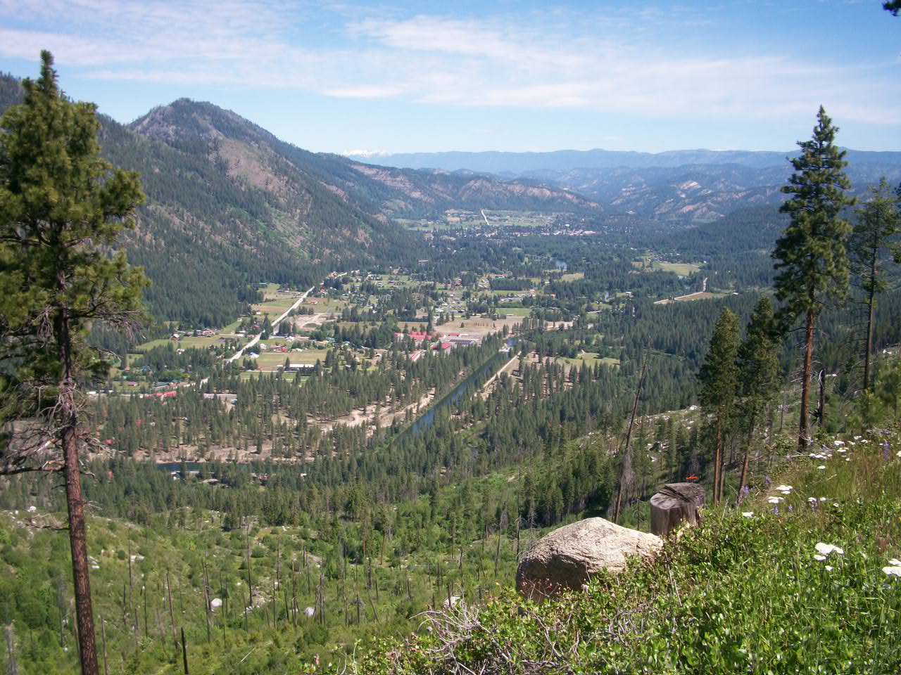
If you opt for the Ridge Ride, you'll shortly find that it's a series of whoop-dees consisting of a mix of single and double track. There are some super brief (yet sometimes heinous) steep ascents/descents which probably can't be avoided one way or the other if trying to not repeat anything, but you'll also almost immediately find that there are a number of rewarding lookouts, too - like these ones above, looking over the Lodge itself and a bit over town. Conveniently, some chairs have been placed (apparently by the Lodge folks) in a few spots; These are nice places to stop and eat or just gaze away. Since you've achieved a few brief and steep climbs to get to them, why not take a moment to pat yourself on the back? Especially do so if you've managed to actually stay on your bike for all of the ascents! More importantly, and making a most pleasant Ridge Ride loop, I'd suggest staying right at the couple of forks you'll encounter, particularly taking the right turn onto the Wapati Trail. That'll eventually allow you to make your way to the Peshastin Overlook.


Not bad, no, this clear shot of Greater Peshastin and down the lower part of the Upper Wenatchee Valley? Indeed. Here below it is even closer, that "little town that could" (do what?, I dunno) called Peshastin:


Coming back from the Peshastin Overlook, I'd suggest again heading right at the point where you had to have branched over to get to the Peshastin Overlook. This will continue you again on Wapati Trail, loping you a little up or on level for a short bit, but then you'll begin a steep drop (sometimes crazy steep) back down toward the Lodge. Stay right at the couple of spots where something branches in from the left and you'll be fine. When you get to the Lodge, which will only take 10-15 minutes, just hit the long driveway down to Mountain Home Road. There is no cafe or such for the public at the Lodge, unfortunately, so a stop there isn't in the cards to poke around much. At the road, you can head back to town (to the right) or hang a left to regain the entrance point where you previously entered the trail system. I'd suggest riding some more!

The OTHER part of the trail system proffers higher and more expansive views, especially from Boundary Butte. After again heading up from the "End of County Road" sign into the system via Access Point Two, take the right at the point where the split to the left is for the Ridge Ride. You'll go for only a short bit before you come to another split, with a well-traversed dirt road heading straight and a considerably lesser one branching off left. You'll want to go straight. (The left one will curl left and up a couple times, with the brush closing in and eventually the trail mostly - if not completely - petering out.)

At times now you'll see Boundary Butte up to your left - it's the one with the cel tower on top of it - as you ride next over a flat section with a ridge alongside you (just barely higher) to the right. (Alternatively, at the beginning of this flat section, where a massive boulder sits to the left, you can access the ridge to the right above via a back way that uses some discreet switchbacks by taking a faint, hopefully-still-ribboned trail to your right.) After less than a mile of this flat trail, you'll come to a marked junction where you can access the ridge to your right quite easily via the Rat Creek Trail. Just take a right to get up onto it. If you do so, you'll next have massive views of the Upper Valley (Leavenworth) below as you essentially backtrack above and along the mile you just did (now to your right). The trail supposedly dead-ends after this slight-but-steady decline, but at its official end, a short and tight set of switchbacks have been put in to allow you to quickly drop back to where you had been when you had started the flat mile-minus done in the (meagre) shadow of the ridge. Take a right to redo this section and come back to the turnoff for Rat Creek Trail you just took.
NOT taking the right to Rat Creek means some easy climbing to the left, now on the Canyon Crest Trail. Eventually this will lead to some nice views of Wedge Mountain and the teeny "high country" valley below it to your right. Those will end when you once again run into a proper road - the Third Access Point into the trail system. From here, head left to climb some over perhaps a mile, finally punching up a short-n-steep grade to access Boundary Butte at over 3000ft. Or, instead, head right where Canyon Crest Trail meets Boundary Butte Road, ignoring a couple of apparent road-like options that'll come in each from the right that will each take you nowhere in a hurry (they are for dirt bikes, apparently). You'll soon come to a junction - "Four Corners" - where you'll need to take a right to head back on Mountain Home Road and back down to town. (Taking a LEFT at Four Corners will take you all the way down to Highway 97 (it's an easier slog back to Four Corners from 97 than from E. Leavenworth Road), while heading STRAIGHT at Four Corners over Mountain Home Road will give you access to Wedge Mountain.)

From Four Corners it's a descent the entire way back to town, supposedly including some 9% grade (I think less) almost right away, which is why I don't suggest necessarily taking the Third Access Point as the way into the system (but over time I increasingly do). The scenery, however, is well worth making a run in this direction. For example, after the initial descent, check out the narrow gauge train track you'll cross with the tunnel entrances to the left - an abandoned tourist trap - before briefly stopping at the sturdy picnic table for a nice overlook. You've earned it. Then head on back into town for your beer(s).
DIRECTIONS: Just over the Wenatchee Bridge heading south/east out of Leavenworth toward Wenatchee, take a right onto East Leavenworth Road. In moments, take the left onto Mountain Home Road and get ready to begin the steep climb in a few minutes. After a few miles, you will come to the entrance to Mountain Home Lodge to the left. This is Access Point One to the system; Access Point Two comes at the end of the county road (marked with a sign) part of Mountain Home Road a mile or so later, where you turn left and up past the gate you can see. That's probably the best entry point, right in the middle of the system of trails with the most options. Access Point Three is a bit further along, after some climbing and more climbing to the junction in the dirt known as "Four Corners". From there you can take a left to directly access Boundary Butte. Technically, you can drive all the way to the top of it - but you better have some good traction for the last bit!
A good loop: Enter the system at Access Point Two, at the "End of County Road" sign. Take a left at the junction for the Ridge Ride. Stay right at the junction in the small clearing (Wapati Trail); head right at the next junction for the Peshastin Overlook. Returning from the overlook, take a right at the junction to continue the Wapati Trail. Stay on trail and head down to the Lodge (staying right when trail comes in from left). From the Lodge come back down to Mountain Home Road and take a left. Re-enter the system at Access Point Two/"End of County Road". Take a right at the junction with the Ridge Ride. Shortly thereafter stay straight when there's the branching to the left. Shortly after this you'll see a big boulder to your right and a faint trail with a ribbon on a tree to your right. Take the tight switchbacks up, then continue on the ridge (Rat Creek Trail) until the trail splits near the end of the ridge. Head left and shortly gain the junction for Canyon Crest Trail and go straight to access that trail. Take that trail until it hits the logging road. Head left until topping out at Boundary Butte. Return on road all the way until the junction of logging roads (Four Corners). Go right and down all the way back to car or town.
Freund Canyon, Ski Hill, And Ranger Road Trails, ~10 miles
This ride's turned into my (and everyone else's) obvious "go-to" ride for the area, one which I sort of did "the wrong way" my first time, back in the early 2000s. That time, I started near Leavenworth's Ski Hill with one of my usual ride cohort, the "Czech-man" M, plus his wife (who goes by K-2 for Top Secret reasons). We ended up connecting the Ranger Road and Freund Canyon trail systems from on high. Little did I know that I'd do versions of that all the time after residing in Leaventown.
Freund Canyon Map needs to be here
What these trails comprise are the ridges found to the east of Highway 2 when entering town from the north/west. As you enter town from the north (Lake Wenatchee/Steven's Pass side), that's Tumwater Mountain immediately to your left as you see the houses and businesses after popping out of uninhabited Tumwater Canyon. Tumwater's ridge continues over and on to the left, eventually looming above the town's Ski Hill area to wend out of sight toward the north with Freund Canyon to one side. As of 2013, the trails are finally reasonably connected - although Freund Canyon will likely be only a shadow of the trail it was until logging completes in 2015. The map shows it all, but you may prefer the text approach to describe what is not a complicated system.
The traditional approach to these trails is to go to Freund Canyon, found by heading up the Chumstick Highway (intersection from Highway 2 is toward the south end of town) for only a short spell after exiting the town. You turn off first onto Freund Canyon Road before taking another left about a mile later onto to the dirt road which you will continue on to where the traditional "counterclockwise" entrance is - another mile or so away. The only problem is that the old "exit" is temporarily a dirt road which has wiped out most of the descent of Freund Canyon. But if you are still doing the trail in its typical fashion, continue on the original dirt road you've been on until it comes to an end, where the trail entrance is marked.


Assuming you are going this traditional way, you'll now climb up "lopingly" as the single track begins. Eventually you'll wisely opt to pass the double-black diamond (seriously: think end-o city or lotsa walking) turn off to the left (that you might not even notice) when you shortly thereafter come to the first switchback to the right. After this bend, you'll next find yourself very briefly on a ridge that lets you look off (back/left) toward Peshastin off in the distance.


After the ridge, now comes a steady climb where you have both views and a large drop off to your right. There are numerous little whoop-dee blips that would be fun in the other direction, but here they pose the smallest of obstacles to routinely gun-n-go over. Eventually, however, you again will switch back hard to the left and have a final rather easy climb to the top of the ride. Here you will find a Freund Canyon sign to remind you that you are actually on the trail, plus a path which goes off away from the trail to the left which you can climb only a short bit for a nice view. (There's also one to the right behind the sign, which is the backward way to head up another black diamond trail that can serve as another entry into the system.) In any event, this is the trail's resting point if there is one.
Now it's downhill time, and that's a good thing. You'll cross water once near the top, but otherwise it's a track that heads only down, down, down. There are numerous rounded corners and places to make small jumps as you might otherwise find yourself tapping on your brakes as you get flying. The angle isn't particularly imposing, so you can really fly through what becomes a rather dusted-out trail as the summer grows long. Except for the fact that much of this is now a road. Closer to the bottom, the dirt gets browner and the foliage gets more broad-leafed as the views finally disappear. Again, the new road has destroyed much of this for now. Eventually, you'll exit what's left of the "trail" when you come to the intersection with the original logging road. Head right to go back to town (if there aren't thimbleberries in season to distract you).


TRADITIONAL FREUND CANYON DIRECTIONS: To get to Freund Canyon, take the Chumstick Highway out of Leavenworth. That's the middle of the town's three lights, located by the German Bakery on the corner. Take the Chumstick just a little under two miles out of town, turning left on Freund Canyon road after the red pole barn that has the sign indicating Freund Canyon is to the left. Follow this for under a mile, up to where you take another left onto a dirt road at another Freund Canyon sign. Now stay left and follow the main track (which will go under an arch announcing the local tree farm) for perhaps 1/2-1 mile, until you see the trailhead to the left (currently a logging road). If driving to the trailhead, this is where you will park and then ride immediately "the wrong way" onto the trail, or continue and ride "the right way" by following the road until its end, where another sign marks the other end of the trailhead.
The RANGER ROAD "Reverse" of Freund Canyon, or exploring above to top out Tumwater Mountain or access other entry points into Freund Canyon: For these rides, you head up steep Ranger Road off of Ski Hill Road, climbing pretty much right from town. Ranger Road is a picturesque beginning to what will be a brief-if-challenging climb - a couple of my favorite Bavarian/Swiss buildings (the barn now burned down as of 2018 or so, unfortunately) are found here:


You'll leave such pleasantry behind quickly, however, as Ranger Road dead-ends into a quickly steep climb which soon ends the pavement. It then swings right to quickly become dirt (ignore the left turn that shortly comes up whose gate is often closed, anyway), then bends sharply left where you could park a car if you didn't just ride over from town. There is a gate here which is closed in wintertime.

The next bit entails a few semi-steep switchbacks, then there's a long north-east run with hillside to your left which next repeats a section of a few more damnable switchbacks that begin where you see a shortly to the left for the first one. The good news is that these are a hair less steep, then there is another "long" north-east run with the hill to your left that offers increasing views of the town below:


That's all well and good, but the best part is that you come to a T junction (2620 ft). Here you have some choices: (a) head left up Tumwater or (b) head right toward Freund Canyon and the newer connector that will drop you down to Ski Hill.
Option (a) is straightforward, as you'll climb for another 5-10 minutes (0.4 mi.) to another junction (2900ft., ignoring the fading trail heading off to the left at one point). At this junction, you can again head left (c) or right (d). Left (c) means just a hair more of the steep climbing before a steady and easy climb to the top of Tumwater Mountain's road (3875 ft.) with its view of Highway 2 below after you hit the end of the road in a kinda cul-de-sac. You're king of the mountain! The true summit is a walk along the ridge to the right.


ONE of these peaks is the top of Tumwater!


Not a bad view of Icicle Ridge, the Enchantments above, and the Wenatchee River blasting through Tumwater Canyon


Not a bad view of the greater town area below.


Sure, zoom on in.


A right (d) at the upper junction means you go on for a ways with views to your right over a gradually climbing road. When you come to a meadow, you can bear right to the trail/road that continues to that side until you see a trail bear off to the right (3370 ft.). That suh-teep trail ("Ribbed") will drop you down onto the top of the Freund Canyon trail from above, where the traditional descent would be to your right. Going left would get you to the same place with more logging road at the end while going straight is just a tiny hitch for a view. Not takeing the right turn at the meadow to Ribbed Trail would mean curling counterclockwise around the meadow and climbing some more, increasing steeper, road. Eventually you'll top out on Tumwater's ridge with the true summit to your left, a small hump-mit to your right, and all of l-ong Drury Falls directly in front of you.
Meanwhile, if heading right at the first junction (b), the road lopes gently upward until you come to the first hard bend to the left, with the hill always to your left. There is a trail that drops down to the right here that I don't know yet. Instead you continue with the hill to your left, now slightly descending for a short spell until you come to the end of the car-navigable road. A right here would be to take the new and heinously steep-at-times ("Rosy Boa") trail which will eventually dump you at Ski Hill if you haven't had a heart attack first at some of the razor ridge sections that I generally opt to walk since I like living.


Some shots from Rosy Boa (above), steadily becoming a better-groomed trail that is seeing the deathly drops offering more reasonable alternatives.


Coming down Rosy Boa, you'll eventually hit an intersection with the new (as of 2013) 4TheBoys trail (seen above, model MTBers not included). Taking a left will eventually intersect you with the new/temporary logging road that's disrupting the old Freund Canyon descent; taking a right will eventually dump you out at the Ski Hill Parking Lot.
More likely, however, you won't take the turn onto Rosy Boa in the first place, instead heading over the hump of dirt to your left to continue following the mountain with the hill to your left and the drop to your right. Several minutes of mostly mild descent will eventually T you right into the Freund Canyon trail. This junction is near the top of the traditional descent, so I often head left to climb for about 10 minutes before topping out and turning around to enjoy the full Freund Canyon descent. Since the normal descent is currently a road, however, in 2013 and until further notice I'd recommend not turning around but heading on to do Freund Canyon in "reverse". You'll eventually hit a logging road, which you'll follow and head down until you hit the pavement of Freund Canyon Road. Hang another right to hit the Chumstick Highway in less than a mile. Take another right and you'll be in town in less than two miles, right by the Bavarian Bakery and Dan's Market.
RANGER ROAD DIRECTIONS: To get to Ranger Road, take Ski Hill Road from Highway 2 (near Kristall's or across from Good Mood Food). You'll first briefly head through town before the houses space out. Shortly after the road begins to climb gently, take Ranger Road to the left (in front of the yellow house with the big Swiss barn behind it). If driving, you will park at the first left switchback shortly after the road turns to dirt. You'll either come back out this way or return via Freund Canyon on the Chumstick (see info above).
SKI HILL DIRECTIONS: From Highway 2, turn onto Ski Hill Road at Krystall's/Wells Fargo Bank. Where the road will take a sharp turn tot he right is where instead you'll head straight into the Ski Hill Parking Lot. Park/continue riding past the trail sign, up the gravel road which will shortly bend to the right. Stay left on this main road, passing the Summer Theater on your left, until you see the intersection with the new trail (4TheBoyz) to the left. Take the trail, heading out under three miles to intersect with the new logging road that was the old Freund Canyon descent. Past midway on this trail is a sharp bend to the left that also has a trail coming in from the left - this is the ridge climb up "Rosie" trail which can take you all the way up to the road which comes from Ranger Road.
Xanadu Trail, ? miles
This ride took forever for me to get to - 12 years after moving to town, somehow - but one July 5th (2022) finally saw me there. Unless doing a small shuttle, it starts with an easy climb that is a continuation of the same logging road you came in on. This'll go for a ways, then, at a junction marked by a cross to Paul on your left (and across from a numbered logging road to the right) you'll take take a turn to the sharp left to almost immediately come to a gate that you'll have to go through one way or another. This section still climbs, but now it's an ever slightly harder ride which you'll chug away on until you get to a curve in the path - which is the exact point that you've been looking at to your left while riding up this section. The disused logging road actually continues beyond this point, bending right, but you'll see the singletrack to your left and this is where the downhill and the real trail begins. You start right away with a rocky razor ridge that drops plenty, at times a dusty or sketchy path with loose rock and a sometimes steep down angle, but it's always manageable even if you just have to walk your bike for a bit. There is one truly scary large rock formation a ways into this section, however, that I imagine you are supposed to ride down, but I chickened out quickly enough to instead walk on its left side. Soon after that, the ridge run comes to an end and what follows is a very swoopy continuation that now lacks views like on the ridge - but is way fun. This section will briefly even climb a bit at one point, but otherwise it's all pretty easy to keep your momentum and a big smile on your face all the way to the end.
To get there, you need to go up the mile or so of paved road that begins Derby Canyon outside of Peshastin (the road coming out of North Road right by where one drives under the train tracks). When the pavement ends, continue on with the logging road for a mile or two, until you come to a fork consisting of two prongs which split the road a bit to both continue forward. Take the right prong, following it for a bit until you see the Derby Canyon trail sign and then a singletrack exit immediately thereafter both to your left side. Park here.
Red Hill, Red Devil, Devil's Gulch and Mission Ridge MTB trails near Cashmere, Washington (<20 miles)

"Where the hell is that Gulch?!?" followed by "I think it's over there..." Boy, if I earned a Benjamin for every time I've said those lines I'd be rich. Yes, I do know that it's behind the town of Cashmere, a burg located in Central Washington between Leavenworth and Wenatchee on Highway 2. I also know to detour from downtown Cashmere to get there and, once you're headed toward the gap in the rising dry mountains properly, you don't have to turn anymore. So what gives? Dunno. MY hazy remnant clue of memory, about a turn after the tiny bridge in town, only sort of helps some times. The Cider Mill sign is similarly a partial ruse toward success. A downtown road construction project doesn't have any place in my cobweb clearing exercise, either, but that's long gone. WTF?!? Well, such fun is now no more - there are signs on how to get to Devil's Gulch, often considered one of if not THE premier trail in the state of Washington. Toward a dozen miles of downhill with some big views of landscapes has a way of doing that.


But it turns out that the area is even better than just that. Over time, by getting lost and exploring equally, I've found that Devil's Gulch is only one part of the fun. In fact, if you head over to the nearby Sand Creek Trailhead, you can find out that Red Hill out-devils the devil in the Gulch! It's like the Gulch, yes, as in there is some good climbing, but this trail's ascent is all on single-track. Its ground is held together better, too, since usually one climbs a logging road to access the Gulch when its lower single-track gets so dusted out. The ruts get a little deep in places, sure, but it stays rideable throughout. Its downhills are nothing short of spectacular, long runs of glory. View after view to survey the surrounding ranges unfold to greet you, one excellent surprise after another - including some askance views of the Enchantments peaks. What a sugar-injected coating of icing over and beyond the sheer beauty of such extended runs! Wow. As for the track itself, it often contains the random ramped turn for a little fun; most of it is generally without rocks and roots. You truly can fly without a care - good as long as no one sails over a cliff. So far I've managed not to.
And then there is the monster: Mission Ridge itself. I'm still waiting to take this one on, but it's bigger and badder than the Devil and the Reds themselves, that I know.
Sometimes it's best to let the pictures tell the story. Here are some from a long day of taking Red Devil to Devil's Gulch, up the Gulch and then returning as we came. Broken chains, a stabbed tire, all grist for the mill in a long day at the 'Gulch. At least I don't face plant near a massive rock as I did once racing down the Gulch with friends around the year 2000. The Gulch can inspire greatness as easily as stupidity.


On that same occasion, when I take a break by a stream I'm eventually surprised by first one, then four, morel pickers. Guatemalans - Guatamatelcos - all, they stop at the stream to clean up a bit before continuing with their workday. Talk about a contrast in uses of the trail! I happily jabber away in Spanish to learn the ins and outs of the trade, which ain't bad: $200 for the 12 hour day, working hard but working with friends for a bit of independent enterprise. The season lasts 3 months. Their baskets are full, in any event, and soon they are off to run into my descending friends.


DIRECTIONS TO THE TRAILHEADS: To get to Devil's Gulch, Red Hill, Red Devil and Mission Ridge trails: Take Highway 2 to Cashmere. From the west or east, take the Aplets/Cotlets exit into town (Aplets Way, the turn after Goodwin if coming from the west or the one after Cottage if coming from the east). This is the main entrance into downtown, with a fake crate of apples on each side of the bridge as you immediately cross the Wenatchee River. Main/Cottage Street appears shortly thereafter to the left (which you don't take) when you hit a stop sign. Instead go straight on what becomes Division street. Follow this road as it bends right and turns into Pioneer Street. Shortly after the bend, you'll see Mission Creek Road, where you'll turn left (there's a small sign for Devil's Gulch). About a quarter mile later turn right at the unmarked T-intersection. Shortly thereafter cross the actual Mission Creek and then take the first left... back onto Mission Creek (where there's another Devil's Gulch sign). Follow this for seven miles (there are mile markers) until the gravel begins at the ramshackle homestead that is apparently a junkyard, complete with mangy fast-breeding dogs and a random folks who seem to live there and do exactly god-knows-what.


No comments:
Post a Comment